This article originally appeared in Desert
Magazine, May 1948--
The day is not far distant when motorists will
be able to roll along a smooth highway to a remote little
village on the gulf shore of Baja California and spend
their winter vacation days boating and fishing and bathing
in the hospitable atmosphere of Old Mexico---at San
Felipe. Here is a progress report on the new highway
to a locale many Southwesterners have long wanted to
visit.
by RANDALL HENDERSON
If those geologists who read the history of this old
earth in the rock formations and the alluvial deposits
have guessed correctly, the space now occupied by thc
Desert Magazine office in El Centro, California was
once many feet below the surface of thc Gulf of California.
This was a very wet spot.
But that was many years ago. The water is now gone,
and Desert's staff is warm and dry –52 feet below
sea level. Paradoxically, it was 0’l Man River---the
turbulent Colorado ---who did the engineering job necessary
to convert the great Imperial Basin, in which El Centro
is located, into one of the driest places on earth.
The muddy river with its delta on the eastern shore,
poured so much silt into the middle of the gulf a great
dam of sediment was formed creating an inland sea on
the upper part of this long slender arm of the Pacific.
After a few hundred years the salt water in this newly
formed sea evaporated, leaving the dry below-sea-level
plain to be discovered by Spaniards who came to the
New World in search of gold.
Then in the 1890's an American engineer, C. R. Rockwood,
came upon the scene and saw the possibilities of converting
this inland basin into farms, watered by the same river
that had created it. Today a half million acres in the
Imperial Irrigation district bear evidence of the soundness
of the idea. The 1947 production from this former gulf
bed was $96,000,000.
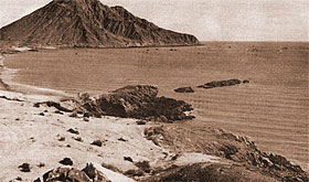
|
Before the lighthouse |
But the gulf---or what is left of it---still occupies
a very conspicuous place on the maps of North America's
west coast. True, it is growing smaller year by year
as the Colorado continues to pour its burden of silt
into the delta at the upper end. But it remains a sizable
body of water and one of the best deep sea fishing places
accessible to American fishermen.
When the boundary lines were set up between Mexico
and the United States, the shorelines of those gulf
fishing waters were allotted entirely to Mexico, and
Americans who would hook the 300 pound tutuava which
are so plentiful there have to travel many miles through
a foreign land, and one of the most arid desert regions
in the Southwest.
There are three roads from the Untied States to the
headwaters of the gulf. The best one is the oiled highway
that runs south from Ajo, Arizona to Punta Peñasco
on the Sonoran coast. Increasing numbers of sportsmen
are following this route each season.
A second road goes south from Yuma, Arizona through
the port of entry at San Luis to Puerto Isabel near
the mouth of the Colorado. This is a sandy road and
it is recommended only for the more adventurous traveler.
The third road starts at Calexico on the California
border and winds south across the delta to the fishing
village of San Felipe, 130 miles away on the Baja Califonia
side of the gulf. This story is concerned with that
road. It is a tortuous trail for an automobile. It is
used mainly for trucking the totuava (sea bass) and
shrimp caught in gulf waters to Mexicali, for reshipment
to southwestern markets. The trip involves 10 to 12
hours of punishing bumps and ruts, with no service facilities
along the way. Only the hardiest of the sports fishermen
ever attempt it.
But a new highway is being constructed from Mexicali
to San Felipe. It was for the purpose of giving Desert
Magazine readers a report on the new road that I made
the trip early in February. For, with a hardsurfaced
highway to San Felipe, this primitive little Mexican
fishing village 130 miles south of the border is destined
to become a popular mecca for both fishermen and tourists.
We had perfect equipment for such an expedition---three
jeeps. Arles Adams, my companion on many a desert exploring
trip, carried Larry Holland and Mike Thaanum as passengers.
Luther Fisher of the U. S. border patrol was accompanied
by two other patrolmen, Bill Sherrill and Harry Nyreen.
My passenger was Glenn Snow, manager of the Automobile
Club of Southern California office in El Centro.
It was still dark when we passed through the Calexico-Mexicali
port of entry at 5:20 a. m. Tourist permits had been
arranged in advance. There is no restriction on American
visitors crossing the line to Mexicali for a few hours.
But for an overnight trip beyond the municipal boundaries
a permit must be obtained either at the Mexican consulate
in Calexico, or at the Mexican immigration office at
the international gate. The cost of such a permit is
10.5 pesos, or $2.10.
Two routes are available for the first half of the
journey from Mexicali to San Felipe. The Laguna Salada
route is 18 miles longer than the direct road by way
of Cerro Prieto and El Mayor. But when the Laguna Salada
lake bed is dry, the longer route is less punishing
to man and vehicle.
We chose to make the southbound journey over the Laguna.
A glow of light was beginning to show on the eastern
horizon as we bumped along over the dirt road through
Mexican fields of alfalfa, cotton and grain stubble.
Fifteen miles out we left the cultivated lands of the
Baja California delta and climbed a low summit pass
through the Cocopah mountains.
Beyond the pass the road turned south across the level
sand bed of the lake, and for the next 68 miles we rolled
along at speed unlimited. This road over smooth baked
earth is a temptation to the driver. But occasionally
there are treacherous pockets of alkali and sand to
trap the unwary. Speed with caution is the rule across
the Laguna.
It is a delightful trip in the early morning as the
sun comes up over the Cucopahs on the east and brings
into sharp relief the rugged escarpments of the Sierra
Juarez on the west. Juarez range is slashed with deep
canyons where two species of wild palms grow in luxuriant
forests along little streams which head down toward
the floor of the desert but always disappear in the
sand before they reach their destination. The desert
escarpment of the Sierra Juarez is a virgin paradise
for the explorer, botanist, geologist, archeologist
and photographer. Its approaches are too rugged for
low-slung cars and picnic parties. One needs a jeep
or a hardy pair of hiking legs to get far into the canyons
of that little known range.
As we neared the lower end of the Laguna we saw a
low embankment across the pass ahead of us. When we
arrived there a few minutes later we discovered this
was the grade of the new San Felipe highway.
The new road, costing millions of pesos, is under
construction for 70 miles south of Mexicali. Part of
the way it is a graded embankment across the overflow
lands. At one place it leaves the floor of the delta
plain and cuts through a pass in the Pinta mountain
range.
We followed the incompleted roadbed a few miles, but
below El Mayor a half dozen construction crews are working
on different sectors and continuous passage on the new
roadbed is still impracticable.
Leaving the new grade we headed south across the great
salt flat which lies around the head of the gulf on
the California side. This flat is composed of Colorado
river silt highly impregnated with salt and alkali.
Imagine a great salty plain so arid not a bug or a blade
of grass lives there, and so vast the curvature of the
earth prevents your seeing across it---and you have
a good picture of the terrain we are covering. It is
as level as a floor, and when wet becomes a bottomless
quagmire.
Little rain has fallen on that area for three or four
years, and the road across the flat is in the best condition
I have known in 15 years. However, there are high centers
in places and it is never possible to roll across this
plain at high speed as one does on the bed of Laguna
Salada.
Once, many years ago, Malcolm Huey and I tried to
cross this salt desert too soon after a rain. We plowed
along in our pickup for miles and finally bogged
down near the middle of it. Then the motor quit and
we were not mechanical enough to fix it. We ran out
of water, but had a bag of grapefruit in the car---and
that is mostly what we lived on for two days until a
fish truck carne along and hauled us into port.
A hundred miles below Mexicali we left the salt plain
and rolled along over the coastal bench which borders
the gulf at this point. Here we caught our first glimpse
of senita (old man cactus) and elephant trees
which grow thickly in the Baja California desert. Desert
vegetation is prolific here, and most of the trees and
shrubs are the old friends of the Lower Sonoran zone
with which we are familiar in the deserts of Southern
California and Arizona---ironwood, palo verde, ocotillo
and creosote. We saw salmon mallow, chuparosa, locoweed
and lupine in blossom. Mexicans call this coastal plain
Desierto de los Chinos--- Desert of the Chinese.
A tragic story lies at the back of that place name.
According to well-confirmed reports, the captain of
a Mexican power-boat many years ago picked up a load
of Chinese at Guaymas on the Mexican west coast. They
wanted to go to Mexicali where many of their countrymen
were, and still are, in business, and paid him well
for the passage. At San Felipe bay the captain put them
ashore and motioned inland. "Mexicali is just over
the hill," he told them. It was rnidsummer and
the Chinese started inland practically without water
or food. Days later two of them stumbled into a cattle
camp many miles to the north. The rest perished from
heat and thirst. Occasionally one comes across an unmarked
grave in that region.
Driving through the dense growth of ironwood, palo
verde and elephant trees one catches an occasional glimpse
of the blue waters of the gulf three or four miles away
to the east. On the west the San Pedro Martir range
rises to an elevation of more than 10,000 feet, capped
by Picacho del Diablo, highest peak on the Lower California
peninsula. Three times I tried to climb that peak from
the desert side, and finally made it to the top with
Norman Clyde in 1937. The story of that rugged adventure
in unmapped mountain terrain will be told in a future
issue of Desert.
Ten miles before reaching San Felipe a side road takes
off down an arroyo to the golf shore at Clam Beach.
The sandy waterline here is strewn with sea shells,
tons of them extending along the shoreline for miles.
I know little about the classification of shells, but
I am sure this place is a paradise for collectors. We
gathered some of the prettiest conches for souvenirs,
and then drove the last leg of our journey into San
Felipe.
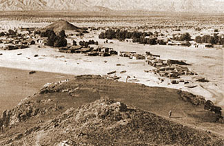 |
Before the real estate
rush. |
It was 3:30 when we arrived at the little shack on
the edge of the settlement which serves as a customs
house, and passed inspection. The Mexican officials
were friendly, but were sorry to inform us that the
water in the gulf was too rough for fishing just now.
They could not understand why anyone would come to San
Felipe if not for fishing. We explained we had driven
down to learn about progress on the new road, and about
the million dollar resort which, according to American
newspaper reports, has been under construction for some
time.
We visited the hotel site, on a bluff overlooking the
bay of San Felipe. It is an imposing site, with an airplane
runway along the beach below. But the only construction
work in progress is a substantial adobe dwelling which
we were told is to be the home of the engineer who is
to erect the hostelry. San Felipe residents --there
are about 1000 of them---were divided in their predictions
as to the hotel. Some were confident it would be built.
Others were skeptical. My own conclusion was that it
hardly would be a feasible project until the new road
to San Felipe is completed--probably in another
year.
Located in a cove on the shore of the bay, the sprawling
village hasn't much to boast about in the way of architecture.
But it is a lovely site, and despite the primitive conditions
of their existence I am sure there are no happier people
on earth than these Mexican fishermen and their families.
Fishing is the sole industry. Trucks from Mexicali
haul ice on the southbound trip, and bring back fish
packed in ice. The fishing season lasts through the
winter months, and when it is over many of the families
return in their boats across the gulf to their permanent
homes in Guaymas and other Mexican west coast ports.
Jose Verdusco, owner of a truck, was having a day
off because there were no fish to haul, and he volunteered
to serve as our guide. We paid a courtesy call at the
home of Francisco Benjarebo de Chica, former police
chief in Mexicali who is now the law in San Felipe.
Then we went to the two town wells, dug in the sand
along the bluff back of the village.
Nature has been kind to the housewives in this remote
hamlet. In one well the water comes to the surface warm.
This is the laundry well, where the women do their washing.
A half mile away another well has cool water for drinking.
All day long the men of the village may be seen trudging
to and from the well with two 5-gallon gas cans strung
on a palanca across their shoulders. To them it is no
hardship that every drop of domestic water must be carried
from the well, perhaps a mile away, along a sandy trail.
Perhaps it is because the chores of everyday living
require constant and arduous labor that San Felipe has
seldom needed the services of a doctor.
San Felipe is a town practically without glass. And
after you have driven over the only road by which glass
might be transported, you will understand this. The
buildings are mostly adobe, with variations of wood
and sheet iron, hauled from Mexicali or brought across
from the Sonora side in boats.
Parties of sportsmen who wish to charter a boat for
fishing are charged from $40 to $50 a day for power
boat and crew plus expert information as to the where
and how of totuava fishing. There is no fixed
fee for individuals who go out as passengers on the
regular daily fishing trip. They settle for a generous
tip to the skipper.
Jose Verdusco took us to the top of a rocky point
which flanks the village on one side, to a little lighthouse
which serves as a beacon for fishermen caught out on
the gulf after dark. The acetylene lamp was located
in a tiny cupola over a shrine where a wax figure of
Guadalupe, patron saint of the San Felipe pescadores,
reposes in a setting of candles and other altar symbols
of the Catholic faith.
Forty-one fishing boats were anchored offshore. There
is no wharf. They were waiting for better fishing weather.
The fishermen loafed on the sand, or repaired their
nets. Wood-cutters with burros make excursions into
the surrounding hills and bring in firewood.
San Felipe lives at peace with itself and the world---untroubled
by lack of such things as running water, window panes,
inside toilets, street lights and motor cars. In American
communities we regard such things as essential---and
often overlook the price in spiritual values we have
to pay for them.
We camped that night a few miles out of San Felipe
near a little forest of elephant trees. We used some
of the dead branches for firewood. This was my first
experience cooking a camp dinner on this species of
wood. It made a brisk warm fire with a pleasing aroma.
On the return trip we followed the same route through
the desert of the ghosts of hapless Chinese and thence
across the great salt wasteland. It was midday and mirages
simmered on the horizon in all directions. Often we
were completely surrounded by "water." Spurs
of the Pinta mountains projecting out into the flat
appeared to be floating islands. A tiny bush appeared
as big as a tree. A car coming from the opposite direction
went through strange contortions. At one moment it resembled
a fat squatty house and the next moment it was as skinny
as a telephone pole.
Below El Mayor we climbed to the newly constructed
roadbed. It has been topped with rock, and although
not finished, it already is a much better road than
the old trail the fish trucks have followed along the
Cocopahs for many years. El Mayor is a little settlement
of three or four crude buildings on the banks of the
old Hardy channel. Since the completion of Hover dam,
the delta is not subject to the annual flood overflow
which spread over the entire delta in former years.
Mexican farmers are bringing more and more of these
fertile delta acres under cultivation, and farms line
one side of the road far below El Mayor.
We wanted to follow the new road all the way back
to Mexicali, but when we reached a point opposite the
volcanic crater of Cerro Prieto, a bridge was out and
we had to detour to the old road to Palaco and thence
to the border gate.
Our log showed 136 miles to San Felipe by the El Mayor
route, and 154 miles by way of Laguna Salada. One may
reach the fishing village by either of these routes,
but it is a punishing trip for a good car. At a later
date when the new highway is completed this will be
an inviting excursion for desert motorists seeking new
landscapes.
Perhaps San Felipe will then have hotels and window
panes and water hydrants and service stations. These
civilized inventions will remove much of the physical
discomfort and mental hazard of a trip to San Felipe.
But I am not sure they will either add to or detract
from the charm of this remote little fishing village
on the shores of the ancient Sea of Cortez.